
![]()
Nutley is among nearly 200 “Victory Towns” being honored for witnessing the historic march of American and French troops to the decisive Siege of Yorktown in 1781, which led to American independence from Britain.
The United States of America has nearly 20,000 incorporated cities, towns, and villages, and yet fewer than 200, less than 1 percent, are what we call “Victory Towns” because they were witnesses to the 700-mile march of American and French troops to Yorktown, Virginia, where they achieved victory in the American Revolution.
Thousands of American and French troops marched through these Victory Towns in 1781, en route to victory at the Siege of Yorktown, Virginia, where they forced the surrender of the British General Cornwallis. It was one of the largest military maneuvers in the United States, leading to the establishment of the world’s first enduring democracy.
For more information visit https://w3r-us.org/victory-towns/
The Yorktown Campaign
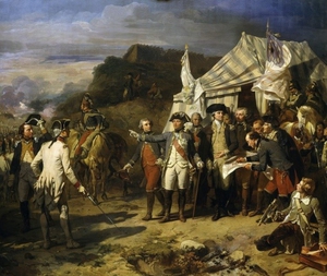
Washington and Rochambeau conferring during the Yorktown Campaign (Art Resources)
The Yorktown Campaign ensured American efforts to win independence from Great Britain would end in success, and elevated General George Washington's notoriety as a result of his role directing the victory. Washington's Continental Army, substantially aided by French land and naval forces, surrounded the British southern army under the command of General Charles, Earl of Cornwallis.
The resulting siege at Yorktown forced Cornwallis' surrender and compelled the start of serious negotiations that ended in recognition of American independence at the Peace of Paris. Washington's fame grew to international proportions having wrested such an improbable victory, interrupting his much desired Mount Vernon retirement with greater calls to public service.
By 1781, Washington's already substantial worries over the health, pay, and morale of his Continental Army stationed outside of New York City were worsened by the success of Cornwallis' southern campaign. Cornwallis' tactical victory at Guilford Courthouse (March 15, 1781) left the Americans destitute of funds, soldiers, and morale. Additionally, former Major General Benedict Arnold, a newly crowned British Brigadier after the attempted surrender of his command at West Point, prepared for Cornwallis' arrival by destroying precious Continental supplies in Virginia. Washington could only watch and wait for an opportunity to attack New York, or wait for a British mistake.
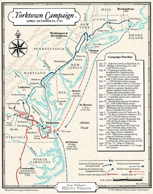
Map: The Yorktown Campaign. (Mount Vernon Ladies' Association)
The opportunity presented itself when Cornwallis entrenched his army at Yorktown and Gloucester Point, near the mouth of the York River in Virginia, with the expectation of reinforcement or evacuation. Washington abandoned his preference for action against New York City upon the advice of French Lieutenant General Jean-Baptiste-Donatien de Vimeur, Comte de Rochambeau, and proceeded south against Cornwallis. Washington and Rochambeau swiftly moved southwards while coordinating with elements of the Continental Army located in Virginia under the command of Major General Marie Joseph Paul Yves Roch Gilbert du Motier, Marquis de Lafayette, and the French Navy under Admiral Francois Joseph Paul, Comte de Grasse. Lafayette fixed Cornwallis in place while de Grasse kept control of Chesapeake Bay, preventing British naval assistance through his victory at the Battle of the Capes (September 5, 1781). In the process, Washington's combined Franco-American army transported from Head of Elk to the lines outside Yorktown.
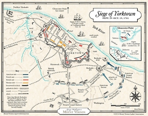
Map: The Siege of Yorktown. (Mount Vernon Ladies' Association)
On September 14, 1781, as reported by Captain Benjamin Bartholomew, "his Excellency Genrl. Washington arrived at 5:00 P.M. when there was twenty one pieces of Canon fired, he review'd the Troops. Washington's southward journey included a visit to his beloved Mount Vernon, his first since the war began six years earlier, before arriving outside Yorktown to supervise the construction of the Franco-American lines. With the opening of forty-one Allied guns on October 9, 1781, Cornwallis' position, already tenuous, was made so indefensible that surrender negotiations started less than a week later on October 17.
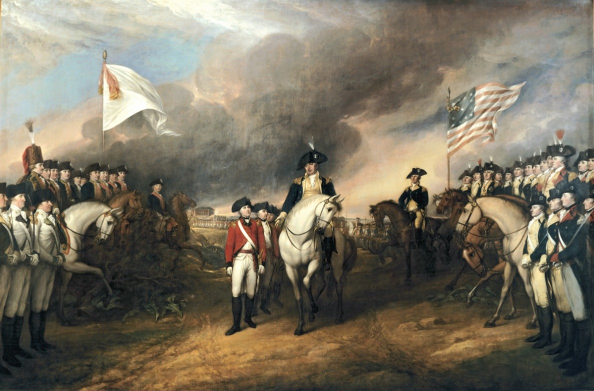
The surrender of the British forces at Yorktown. Painting by John Trumbull (US Capitol)
The surrender of over 7,000 British troops on October 19, 1781 did not end the war. The end came in 1783 after Washington moved back to New York City, with the Peace of Paris signed by a British government installed largely as a result of Washington's victory. Victory at Yorktown, however, brought Washington the increased political clout needed to avert a potential officers' rebellion at Newburgh, conduct the remainder of the war, and after a short retirement to Mount Vernon was the logical choice to oversee the Constitutional Convention and become the first President of the United States.
Nutley Victory Route
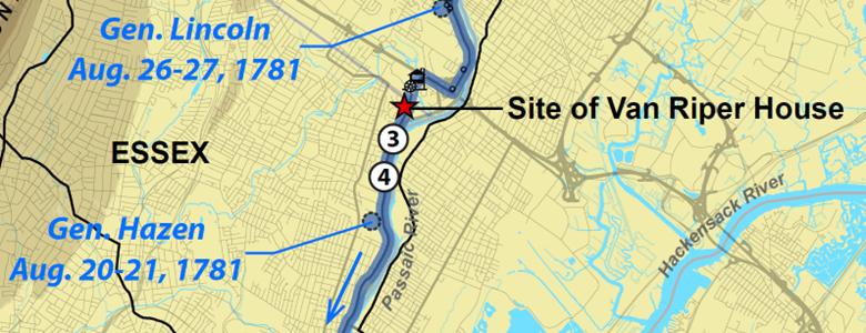
Nutley’s Historical Sites
Nutley Revolutionary War Soldiers Memorial
Corner of Franklin Ave. and New St.
In front of Nutley High School
- Map / Directions to the Nutley Revolutionary War Memorial
- Map / Directions to all Nutley Revolutionary War Sites
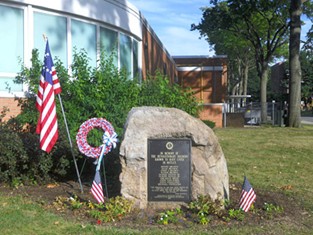
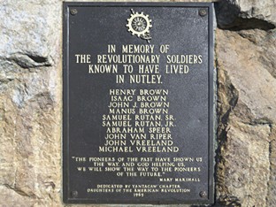
This memorial which stands in front of Nutley High School pays tribute to ten Revolutionary War soldiers who lived in what is now the township of Nutley. However, Nutley did not exist at the time of the Revolutionary War. It was then a sparsely-populated area that was part of Newark, which was much larger than it is today. The area that is now Nutley incorporated as Franklin Township in 1874, and then officially changed its name to Nutley in 1902.
The memorial was dedicated at a ceremony on Washington's Birthday, February 22, 1965. The ceremony began inside the High School auditorium, and then moved outside for the presentation of the bronze plaque. Among the more than 250 attendees were a number of descendants of the soldiers listed on the memorial. Harry W. Chenoweth, who was then the mayor of Nutley, spoke at the ceremony.
Three of the veterans listed on the plaque — John Van Riper, Abraham Speer, and Michael Vreeland — lived in houses which are still standing in Nutley.
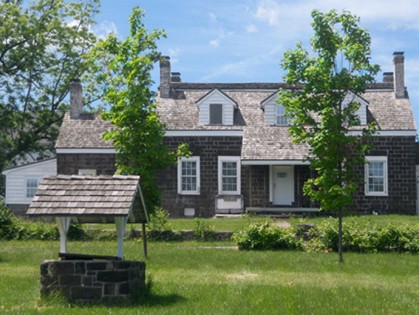
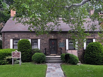
Van Riper House
491 River Rd.
The Van Riper House is currently being restored, and is not open at this time.
For more information about the house and its history, see the Van Riper Restoration Trust website: www.vanriperrestorationtrust.wordpress.com/
The Revolutionary War at the Mouth of the Third River
The Third River locale saw considerable activity for much of the Revolutionary War, book-ended by the American retreat and British/Hessian pursuit of the Continental Army in late November 1776 and the French and American armies’ advance to Yorktown in late August of 1781. For a few months before and many months after these two major military movements through the Passaic Valley, and throughout the intervening period, troops of both American and British persuasions passed along River Road on numerous occasions, disrupting
local farms and businesses, and laying claim to forage, livestock, lumber and various household goods and farm equipment.19 The Van Ripers and their many relatives in the neighborhood were on the receiving end of much of this depredation, most of them lining up on the patriot side of conflict and several entering into military service Following the fall of Fort Lee to the British on November 19, 1776, American forces withdrew southwest across
New Jersey, establishing a defensive line at the Delaware River. The Continental Army retreated through New Bridge Landing, proceeded on to Acquackanonk Landing, where they destroyed the bridge over the Passaic River on November 21-22 to obstruct the British pursuit, and then headed south to Newark, regrouping there on November 23. In the immediately following days, British forces gathered on the east bank of the Passaic, just above its confluence with the Saddle River, crossing over to the west side on November 26 at a fording point upstream of Gothum (present-day Passaic City), and moved on south through Acquackanonk Landing and Third River to Newark. The British encamped briefly at Gothum and plundered and pillaged their way down the west bank of the Passaic from Slooterdam to Second River and beyond.
The cluster of properties around the mouth of the Third River, many of them in Berry or Van Riper family hands, experienced their fair share of British ransacking, which occurred mostly on November 26-28. The extent of the damage is reflected in the claims for compensation made by residents to the New Jersey legislature beginning in 1781. Marinus Van Riper, Garret Van Riper, Richard Van Riper and Richard J. Van Riper, all of whom lived in the Third River/Acquackanonk Landing vicinity, filed claims, although John A. Van Riper evidently did not (in itself maybe an indication that the Van Riper House, the subject of the current study, was not yet in existence). Interestingly, John Berry’s gristmill also does not figure as the subject of a damage claim, leaving a question as to why this particular facility might have been left unscathed.
Largely as a result of River Road being such a critical thoroughfare, American military cartographers, under the direction of former Ringwood ironmaster Robert Erskine, produced several extraordinarily informative and accurate maps of the section of the Passaic Valley extending downstream to Newark from the Great Falls. The route map From Newark thro’ Aquacknonk [sic] to Gothum, surveyed in 1778, shows the course of River Road in precise detail and locates the principal houses and other buildings along its frontage. Immediately upstream of the road’s crossing of the Third River “Jno. Berry’s Mill” is shown positioned on the left (north) bank with a building, probably the miller’s house, on the opposite side of the creek. To the north, alongside River Road, are numerous buildings, only one of which is identified with an owner (Richard Freeland [Vreeland]). To the south of the mill is a dwelling under Vandyke ownership and the Halfmoon Tavern. No buildings are shown in the vicinity of the Van Riper House when, if one had been in existence, it would almost certainly have been depicted. A road is shown heading inland from River Road close to the site of the Van Riper House. This possibly marks the southern limit of the 147-acre tract of John Bradbury that was passed down to and divided among his children and grandchildren, eventually resulting in the property owned by John A. and Leah Winne Van Riper. The Erskine road map is sufficiently accurate that it can be georeferenced and superimposed over modern aerial mapping, providing a clear sense of how the historic course of River Road and key Revolutionary War-era buildings relate to the present-day landscape.
British cartographers, in contrast to Erskine, mostly compiled their maps of the Passaic Valley and northern New Jersey from older, pre-existing cartographic sources available to them in the relative comfort of Britishheld New York City. As a result, their accuracy, topicality and detail suffered and they show the road network and drainage pattern in much sketchier fashion. John Hills’ A Sketch of the Northern Parts of New Jersey, completed in 1781, drew heavily on other maps, such as those produced by Benjamin Morgan and Thomas Millidge, and made an attempt at showing individual dwellings and mills. This map, for what it is worth, also shows no sign of a building at the site of the Van Riper House.
As supporters of the patriot cause, multiple members of the Van Riper family saw military service during the Revolutionary War, enlisting in the Essex County militia. John A. Van Riper and his younger brother Philip both served as privates and John appears to have worked as a teamster attached to the quartermaster’s department in Rahway. The two brothers are recorded as lodging certificates for depreciation of their “continental pay” in the county militia in 1784 as part of the post-war settling of military accounts. Among their numerous cousins living nearby who served in the militia, two stand out for their wartime contributions: Richard (also referred to as Derrick and Richard L. [Jan]) Van Riper (c.1750-1803), who attained the rank of Captain for service in the Flying Camp in 1776; and Harmon (Harmen) (1761-post-1794), who served several monthly tours as a private, participating at the battles of Connecticut Farms (June 7, 1780) and Springfield (June 23, 1780). At Springfield, Harmon endured the traumatic experience of seeing two of his compatriots, Moses Smith and Harmon Brown, felled by a British cannonball.
After the American retreat and British/Hessian pursuit through Third River in late November of 1776, there were many episodes of troops moving back and forth along River Road over the following five years. For example, on Sunday, September 14, 1777, a large British force under General Henry Clinton passed through Third River en route to Slooterdam, scouring the surrounding landscape for forage and livestock. This was part of a multi-pronged British attempt to suppress rebel support in northern New Jersey and lay waste to farms and businesses supplying sustenance to American troops. In early July of 1778, following the indecisive Battle of Monmouth and the British army’s retirement to New York City, American forces moved up the Passaic Valley into Essex and Bergen counties to cement their hold on the New Jersey Highlands. This resulted in Lord Stirling establishing his headquarters at nearby Acquackanonk Landing for several weeks in the fall of that year. Other forays and skirmishes occurred up and down the valley in 1779 and 1780, but the pervasive uncertainty in the local residents’ daily life finally eased in the fall of 1781 as the American and French armies mobilized for their advance south to Yorktown. While the bulk of these troops passed well to the west through Pompton, Morristown and Chatham, contingents of American soldiers under Generals Hazen and Lincoln rolled down the River Road through Third River on August 20-21 and 26-27, on their way to joining Washington’s main column in Springfield.
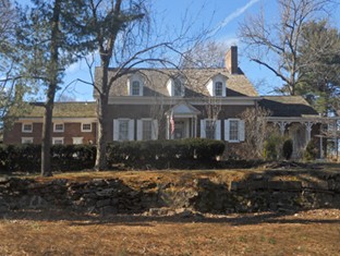
Vreeland Homestead
216 Chestnut St.
Contact the Nutley Historical Society for more information about tours and special events.
The Vreeland Homestead stands between the Nutley Police Department and the entrance to Memorial Park (commonly known as the "Mud Hole"). A plaque which was placed on the building in 1935 notes its Revolutionary War significance. However, most of the plaque's information is now considered to be incorrect.
The house was built by Hendrick van Giesen, most likely circa 1751, making it nearly a quarter-century old at the start of the war in 1775. As indicated on the plaque, it was once believed that the Van Giesens who lived here were Loyalists during the Revolutionary War, and that their property was confiscated from them for this reason. (Loyalists were Americans who remained Loyal to the British in the Revolutionary War.) However, it now seems likely that the Van Giesens who lived here were not Loyalists, and that the property was never confiscated. The homestead and its surrounding eighty-acre property were in fact sold in a legal sale by Hendrick Van Giesen's brother Abraham to Captain Abraham Speer on October 6, 1783. Speer served as a captain of the Second Regiment, Essex County Militia, during the Revolutionary War.
On the day that Captain Speer purchased this house, the Revolutionary War had been officially over for several weeks, but interestingly no one in New Jersey knew it yet. On September 3, the Treaty of Paris had been signed, officially ending the Revolutionary War, although due to the slowness of ship travel across the Atlantic Ocean at that time, the news of the treaty's signing did not reach America until October 31.
Captain Speer only owned the house briefly. He quickly sold the house and twenty-seven acres of the surrounding property to his brother-in-law John M. Vreeland, who had served as a private in Captain Speer's militia company in the Revolutionary War.
The house remained in the Vreeland family until the early 1900's. The Women's Club of Nutley began renting the house In 1912, and purchased it in 1923. It was used by the Women's Club until 2012, when it was turned over to the Nutley Historical Society. It is now occasionally open to the public for special events.
Other Captain Abraham Speer House in Nutley
Captain Abraham Speer owned another house in Nutley which is still standing. That house is located on Church Street near Bloomfield Ave, but it is a private home which is set back from Church Street and is not visible from the street. It is believed to have been built circa the 1760's for Abraham and his bride Emmetche Wouters by Emmetche's father. Abraham lived in the Church Street house until his death in 1834. He is buried several miles from here in the Belleville Reformed Church Cemetery.
Kingsland Manor
3 Kingsland St.
See the Kingsland Manor Facebook page for information about upcoming Events and Open Houses or contact KingslandManor@KingslandManor.org.
Private tours can also be arranged.
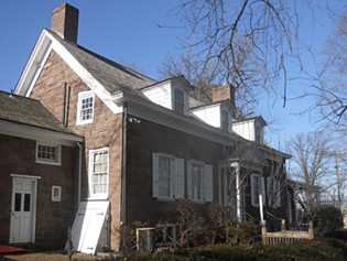
Kingsland Manor is located next to Kingsland Park, overlooking the waterfalls on the Third River, which flows through the park. The oldest portion of Kingsland Manor was built circa 1768, seven years before the Revolutionary War began. The house was much smaller at that time, and in fact stood at a different location — about a mile upriver from here, near a mill in what is now Memorial Park (commonly known as the Mud Hole). Soon after that smaller version of the house was constructed at that site, it was taken apart. The pieces were then floated downriver to this site, where the house was reconstructed. The original owners of the house were James and Mary Walls. James and Mary continued to live at the house throughout the Revolutionary War years.
As described in the Van Riper House entry above, the Continental Army retreated down what is now River Road in November 1776. River Road is less than a half-mile from the Kingsland Manor, so It is likely that James and Mary Walls may have been aware of the thousands of soldiers marching by. It is also possible that some of the soldiers may have ventured off from the main road and passed by closer to the house. However, this is only speculation, because there is no recorded information about the Walls's experience of the November 1776 retreat.
When the war came to an end in 1783, the Walls still owned the house. Around 1787-1790, the house was purchased by Joseph Kingsland, who was part of a Kingsland family who had been settlers of the area that is now Lyndhurst. During the Revolutionary War, Joseph had left the country to live in Nova Scotia, which implies that he was either Loyal to the British, or he was simply neutral and wished to avoid the war altogether.
It is important to remember that many Americans were not strongly pro-Independence during the war. It has been estimated that 1/3 of the population were pro-Independence, 1/3 remained Loyal to the British, and the other 1/3 were somewhat neutral. These divisions sometimes occurred within families, including the Kingslands. While Joseph had left the country during the war, other members of the extended Kingsland family fought on the American side. Joseph's wife, Mary Outwater was the first cousin once removed of Captain John Outwater, a noted officer of the Bergen County militia during the war.
After the war, Joseph returned to the United States and moved to New York City. Joseph purchased the Kingsland Manor and approximately 23 acres of surrounding property between 1787-1790. He continued to live in New York City for several years while improvements were made to the Kingsland Manor. He and his wife moved into the Kingsland Manor in 1796. The Kingsland family continued to live here until 1909. Over that time, alterations and expansions were made to the house.
Kingsland Manor is now operated by the Historic Restoration Trust of Nutley, who open the house to the public for occasional open houses and events. The interior of the Kingsland Manor reflects all periods of its history. The house had a colorful history after its Revolutionary War-era beginnings, including that it was used as a speakeasy during Prohibition. I recommend a visit to the house when it is open, to experience firsthand the history of this Nutley Landmark. For more information about upcoming events, see the Kingsland Manor Facebook page or contact KingslandManor@KingslandManor.org.
